
Dorothy, Alberta
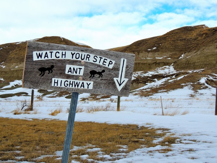
Personally, I didn’t even know we had a designated Ant Highway in Southern Alberta, but the little wooden sign pointed the way…
Our initial goal was to visit Reptile World located in Drumheller, Alberta, approximately an hour and a half northeast of Calgary in the midst of the Alberta Badlands; however, this would not be the case. Instead we found ourselves randomly driving along Highway 10 (also known as the Hoodoo Trail) in search of adventure.

The Atlas Coal Mine
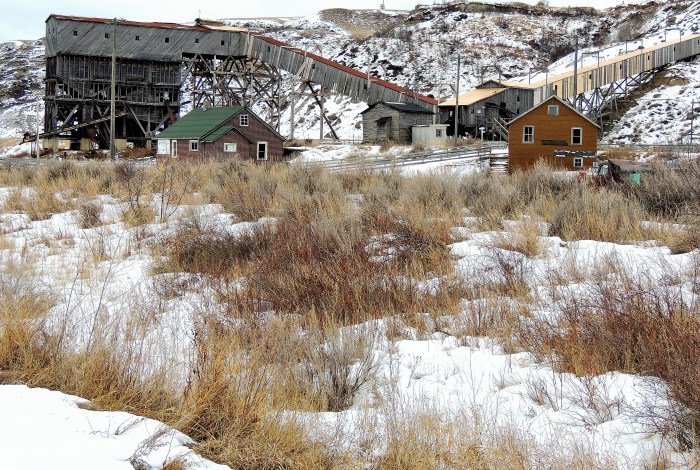
The Atlas Coal Mine

The Atlas Coal Mine
Even though this stretch of road covers only 22 kilometers, it is 22 kilometers of amazing history. Whether you are a scientist, historian, photographer, or just driving through the Alberta Badlands on your way to another destination, the badlands has something for everyone. Formed millions of years ago, the coulee landscape is constantly changing, providing a unique backdrop to our endless prairie lands. As one drives south along the Hoodoo Trail, one begins to understand how this landscape must have looked millions of years ago. As the winds and water continue to wash away the outer layers, one can see the numerous deposits of sediment that plays an important part in our fossil fuels. In addition to the scuplted hoodoos; continuous dinosaur findings have made our Alberta Badlands famous around the world.
Dorothy, Alberta
Drumheller became a coal mining mecca back in the 1920’s and later developing into a city in 1930. With this boom, various mining operations sprouted along the highway and little hamlets soon followed.
I made the Atlas Coal Mine my destination point along this highway. The Coal Mine is a 24 kilometer scenic drive from Drumheller. Along the way, you will drive along the Red River valley that winds its way through the Badlands landscape. Personally, I had never been down this route and I was very excited to see the outcome. Although the day was rather dreary, we continued our adventure paying no attention to the overcast sky.
Finally, in the distance, we could see the Coal Mine, a wooden structure standing resiliently against the moon-like landscape. As we drove my son told me stories about the mine and the various tours it offers. You might be thinking, if I had never been, why was my son so versed with information regarding this mine. Well, my son has been attending the Royal Tyrrell Museum Science Summer Camp for years and each year they spend a day at this particular mine. Personally, the Museum could be a blog all its own, so to stay focused I will continue with the mine experience. The Atlas Coal Mine is open from May to October and offers underground tours, train tours, and tipple tours. So, being February the mine is closed, however, you can still drive up and walk around the grounds that haven`t been closed off. The area provides an excellent rendition of what that era would have been like and the conditions men and women worked through.

Dorothy, Alberta
Our original plans dictated that we would turn around at this point and drive back to Drumheller since this was the end of Highway 10, but no, my son wanted to travel further south along a secondary highway # 570. 13 kilometers up the road was a town named Dorothy, I told my son we would stop there and turn around. Why did I want to turn around there? Well, for the first time ever, I forgot the map – I don’t own a GPS – that’s right, I do it the good-old fashion way, well, unless I’m driving internationally and then I will splurge on a rented GPS. Back to the story…
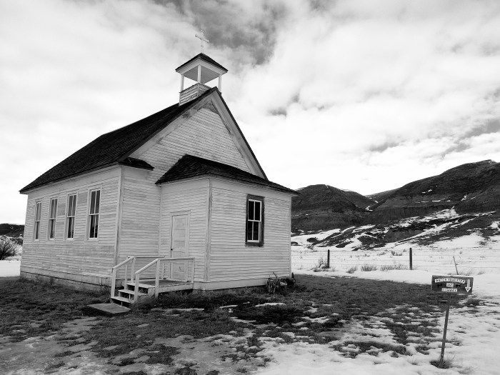
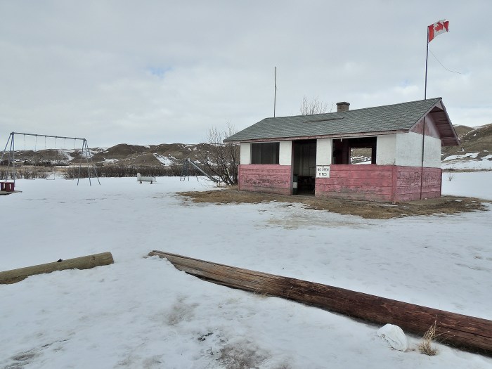
We come across the road sign that stated “Dorothy”. However, as we slowed down we didn’t see a town, a few buildings and an old decrepit grain elevator, yes, but that was all. Not scared of the unknown, I slowly drove down the road and assessed the surroundings. There was an old church, a few lived-in houses, a forgotten playground and grocery store, and some other wooden structures that made up the ghost town of Dorothy. At one time, Dorothy must have played an important part of this area, but now, swallowed up by mainstream Alberta, this town is slowly being forgotten.

Dorothy, Alberta
Dorothy, Alberta

Dorothy, Alberta

Highway 10

Highway 10

Highway 10

Suspension bridge along Highway 10
Hoping not to get stuck in the snow, I drove towards the old church. With the badlands providing the backdrop, I knew I would get some great shots. As the wind churned around us providing a nasty wind-chill we persisted and snapped some shots. My son ran off and brought back to life the playground equipment scattered around an old community picnic area as I snapped more and more pictures. Eventually, the wind chill became too much and we once again found shelter in our warm car. After driving down the two streets, we decided to make our trek back to Drumheller. However, the landscape was too beautiful to leave behind and we found ourselves turning off onto dirt roads to capture the beauty of the badlands and the surrounding areas. At one point during our drive, my son noticed an old abandoned TV in the middle of nowhere – so of course we had to stop and snap a picture. As we continued our journey, we stopped to check out the suspension bridge before heading home. By this time, it was late afternoon and we decided to head on back to Calgary. We knew we would be back to explore during the warmer months, besides, the landscape wasn’t going anywhere, what’s a few months when you are talking millions of years!
Categories: Alberta Road Trips, Around Alberta, Road Trip Pictures

Awesome story and amazing pictures as always! You and K are so adventuresome. Thank you for sharing your travels with us.
Thank you, I love to share!
We took a day trip out of Calgary to hoodoos and a suspension bridge that looks exactly as the one here – I don’t know exactly where we went that day and I haven’t been able to figure it out via the internet. There was a town, with a huge dinosaur statue, hoodoos, a suspension bridge … I don’t think it was Drumheller … can YOU tell me where I was? 🙂 Exactly where was that suspension bridge?
The suspension bridge is located off Highway 10 in the hamlet of Rosedale – just south of Drumheller.
There are hoodoos throughout the area; however, the hoodoos in this post were photographed at a view point as you approach The Atlas Coal Mine.
Also…there are a number of dinosaur statues in that area; however, the most prominent one is located in the town of Drumheller (which is a post all its own). Story goes, that dinosaur is the largest one in the world.
Happy travels, it’s a great area to explore.
Thanks for following!
All the best,
Thanks for the reply – still trying to narrow it down 😉
I love the picture of the church-great contrast and details,and the grain elevator image is terrific! All good, but these two really stand out for me.
Thank you! I had lots of fun taking the photos!